 Waterholes Canyon is located on the Navajo Reservation near Page, AZ. The slot is in Navajo sandstone and the lower canyon is popular for having many beautiful features including classic tight twisty narrows, potholes, and a beautiful 320′ rappel down a patinaed wall. As an added bonus, Waterholes Canyon ends at the Colorado River in Glen Canyon National Recreation Area 3-1/2 miles above Lee’s Ferry at the start of the Grand Canyon. It requires a packraft float exit. The technical slot begins where Highway 89 crosses Waterholes Canyon about 4 miles south of Page.
The dramatic increase in popularity of Horseshoe Bend a few miles away has led to an increase in rescues of parties not aware of the technical nature of the lower canyon. The advanced nature of the Waterholes canyoneering descent has also led to at least one rescue of a technical team at the 320′ drop location. The Coconino County Sheriff’s SAR team has been the responding rescue organization. The Navajo Tribe has become concerned about the number of rescues and has been considering mitigating options for lower Waterholes Canyon, including closure. Upper Waterholes Canyon, east of the Highway 89A crossing, is non-technical and has now been opened to guided use only by Navajo guides. Please do not enter upper Waterholes without an authorized guide.
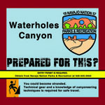
The Coalition of American Canyoneers, the Coconino County Sheriff’s SAR coordinator, and Navajo Tribe Lake Powell Tribal Park representatives met in Page in January 2018 to discuss options to remedy the rescue problem in lower Waterholes. It was agreed to begin by educating the public about the technical nature of the lower canyon in the hope that unqualified people wouldn’t enter. Signs were created by the Coconino County Sheriff’s SAR team, funded by CAC, and will be installed by the Navajo tribe to educate canyoneers about the technical challenges. Educational flyers with canyon beta and safety tips were funded and printed by CAC to be distributed by the Tribe when Waterholes permits are issued. Eventually, an educational video about the canyon hazards will be made and will be required viewing to get a permit.
The Navajo permit office is under construction and interim procedures are being used until the new facility is completed next year. The permit currently costs $12 per person. The office is open M – F at 8:00 a.m. Navajo (MST) time. Please call 928-645-0904 for the current location. Canyoneers seeking a Waterholes permit will be required to show the Tribe the technical gear to be used in the canyon before a permit will be granted. Please be aware that only certain individuals in the permit office are authorized to issue Waterholes permits. Call ahead to ensure the appropriate individuals will be available before picking up your permit. It will take time to iron out these processes, but Waterholes is open for technical descents.
The area around Waterholes Canyon has become quite busy with the increase of tourism around Horseshoe Bend. As a result, the Arizona Department of Transportation now forbids parking on the side of Highway 89 for safety reasons. We are working with Navajo Parks representatives to establish a permanent parking solution. In the interim, either have somebody drop you off at the bridge over the canyon or ask the family who guides upper Waterholes Canyon for permission to park in their lot immediately east of the bridge behind the barb wire fence. If you are granted parking permission you may be asked to pay a parking fee which has been $10 per vehicle most recently. If you believe you’ll arrive back at your vehicle after 5:00 p.m., which is quite likely given the length of the loop, be sure to arrange with the guide family for access to your vehicle after hours before you begin the Waterholes descent.
We require your help to keep it open. Know that your skills, and others in your party, are up to the task of safely descending Waterholes Canyon before applying for a permit. Please be respectful of Tribal employees as this process is refined.
Your membership makes a difference!
We regularly deal with land managers, national park officials, and politicians. The broader our membership base the greater our impact.

